 Harun
Harun
Current Status
Where is the vessel?
Harun is currently in Near San Juan de Nieva, based on AIS data received about 15h ago.
Latest AIS update:
Current position: 43.56382° N, 5.91809° W (Near San Juan de Nieva)
Average speed (last 7 days): Loading…
Average speed (last 30 days): Loading…
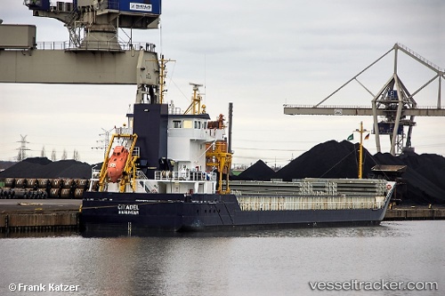
Vessel profile: Harun is a Multi Purpose Carrier with dimensions 111m x 15m.
This page combines live AIS, route history, probable destination signals, nearby traffic, and port activity for practical vessel monitoring.
The current position of vessel Harun is 43.56382 lat / -5.91809 lng. Updated: 2026-07-09 18:00:16 UTCNearest reference points:
- Near San Juan de Nieva
- Near Musel-Arnao
- Near Tremanes
Currently sailing under the flag of Cyprus ![]()
Harun built in 2008 year
Deadweight:
6000 tDetails:
Live Vessel Harun Analytics (details, animations, etc.)
Recent AIS points (UTC):
2026-07-09 06:01:44 UTC · 43.59817, -5.98517 · SOG 0.4 kn · COG 4°2026-07-09 07:32:23 UTC · 43.59852, -5.98625 · SOG 0.7 kn · COG 57°
2026-07-09 07:50:31 UTC · 43.59832, -5.98595 · SOG 0.6 kn · COG 30°
2026-07-09 18:00:16 UTC · 43.56382, -5.91809 · SOG 0 kn · COG 354°