Tour 2
Current StatusWhere is the vessel?
Tour 2 is currently in 42 nm SE of Pinghai, based on AIS data received about 14h ago.
Latest AIS update:
Current position: 21.97213° N, 115.16251° E (42 nm SE of Pinghai)
Average speed (last 7 days): Loading…
Average speed (last 30 days): Loading…
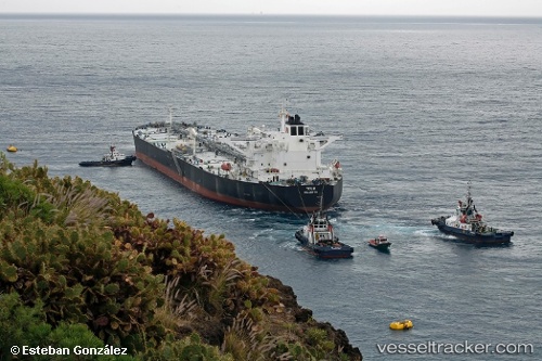
Vessel profile: Tour 2 is a Crude Oil Tanker with dimensions 48m x 274m.
This page combines live AIS, route history, probable destination signals, nearby traffic, and port activity for practical vessel monitoring.
The current position of vessel Tour 2 is 21.97213 lat / 115.16251 lng. Updated: 2026-05-22 12:26:28 UTCNearest reference points:
- 49 nm S of SHANWEI
- 14 nm S of Pinghai
- 25 nm SE of Wan Tsai
Details:
Live Vessel Tour 2 Analytics (details, animations, etc.)
Recent AIS points (UTC):
2026-05-22 10:05:29 UTC · 21.97247, 115.16290 · SOG 0 kn · COG 285°2026-05-22 10:05:29 UTC · 21.97247, 115.16290 · SOG 0 kn · COG 285°
2026-05-22 11:47:27 UTC · 21.97216, 115.16279 · SOG 0 kn · COG 288°
2026-05-22 12:26:28 UTC · 21.97213, 115.16251 · SOG 0.2 kn · COG 287°