 vesseltracker.com
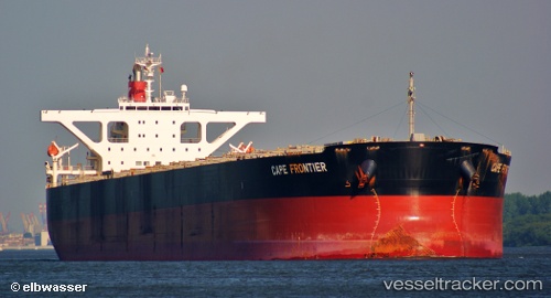
Imperial Frontier
Current StatusWhere is the vessel?
Imperial Frontier is currently in 285 nm W of Iba, based on AIS data received about 16h ago.
Latest AIS update:
Current position: 14.98148° N, 115.06162° E (285 nm W of Iba)
Average speed (last 7 days): Loading…
Average speed (last 30 days): Loading…
Vessel profile: Imperial Frontier is a Bulk Carrier with dimensions 45m x 289m.
This page combines live AIS, route history, probable destination signals, nearby traffic, and port activity for practical vessel monitoring.
The current position of vessel Imperial Frontier is 14.98148 lat / 115.06162 lng. Updated: 2026-05-17 22:16:35 UTCNearest reference points:
- 282 nm E of Tan Cang Qui Nhon
- 222 nm W of Iba
- 232 nm E of Tan Cang Qui Nhon
Details:
Live Vessel Imperial Frontier Analytics (details, animations, etc.)
Recent AIS points (UTC):
2026-05-17 22:16:35 UTC · 14.98148, 115.06162 · SOG 13.2 kn · COG 210°2026-05-17 22:16:35 UTC · 14.98148, 115.06162 · SOG 13.2 kn · COG 210°
2026-05-17 22:16:35 UTC · 14.98148, 115.06162 · SOG 13.2 kn · COG 210°
2026-05-17 22:16:35 UTC · 14.98148, 115.06162 · SOG 13.2 kn · COG 210°