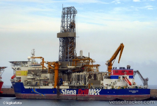
 STENA DRILLMAX
Current Status
Where is the vessel?
STENA DRILLMAX is currently in Near Caracas Baai, based on AIS data received about 14h ago.
Latest AIS update:
Current position: 12.07333° N, 68.86383° W (Near Caracas Baai)
Average speed (last 7 days): Loading…
Average speed (last 30 days): Loading…
Vessel profile: STENA DRILLMAX is a Drilling Ship with dimensions 229m x 42m.
This page combines live AIS, route history, probable destination signals, nearby traffic, and port activity for practical vessel monitoring.
The current position of vessel STENA DRILLMAX is 12.07333 lat / -68.86383 lng. Updated: 2026-05-19 07:22:06 UTCNearest reference points:
- Near Bullenbaai
- Near Las Piedras
- 24 nm NW of Palm Beach
Currently sailing under the flag of United Kingdom ![]()
STENA DRILLMAX built in 2007 year
Deadweight:
97000 tDetails:
Live Vessel STENA DRILLMAX Analytics (details, animations, etc.)
Recent AIS points (UTC):
2026-05-19 04:03:04 UTC · 12.07333, -68.86383 · SOG 0.1 kn · COG 346°2026-05-19 04:10:46 UTC · 12.07333, -68.86383 · SOG 0.1 kn · COG 345°
2026-05-19 05:38:25 UTC · 12.07333, -68.86383 · SOG 0 kn · COG 346°
2026-05-19 07:22:06 UTC · 12.07333, -68.86383 · SOG 0.1 kn · COG 346°