 Normand Seven
Current Status
Where is the vessel?
Normand Seven is currently in 12 nm NW of Essungo Terminal, based on AIS data received about 14h ago.
Latest AIS update:
Current position: 6.23271° S, 11.98996° E (12 nm NW of Essungo Terminal)
Average speed (last 7 days): Loading…
Average speed (last 30 days): Loading…
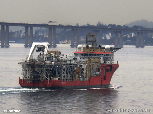
Vessel profile: Normand Seven is a Pipe Layer with dimensions 128m x 28m.
This page combines live AIS, route history, probable destination signals, nearby traffic, and port activity for practical vessel monitoring.
The current position of vessel Normand Seven is -6.23271 lat / 11.98996 lng. Updated: 2026-05-20 02:04:44 UTCNearest reference points:
- Near SOYO
- 11 nm W of Cabinda
- Near Futila Terminal
Currently sailing under the flag of Norway ![]()
Normand Seven built in 2007 year
Deadweight:
14180 tDetails:
Live Vessel Normand Seven Analytics (details, animations, etc.)
Recent AIS points (UTC):
2026-05-19 22:43:15 UTC · -6.22928, 11.95482 · SOG 0.1 kn · COG 199°2026-05-20 00:01:13 UTC · -6.22971, 11.97165 · SOG 1 kn · COG 198°
2026-05-20 01:06:34 UTC · -6.23086, 11.98288 · SOG 0.9 kn · COG 199°
2026-05-20 02:04:44 UTC · -6.23271, 11.98996 · SOG 0.8 kn · COG 199°