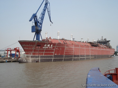
 Dapeng Star
Current Status
Where is the vessel?
Dapeng Star is currently in 310 nm S of BENETE, based on AIS data received about 14h ago.
Latest AIS update:
Current position: 14.04500° S, 116.29500° E (310 nm S of BENETE)
Average speed (last 7 days): Loading…
Average speed (last 30 days): Loading…
Vessel profile: Dapeng Star is a Lng Tanker with dimensions 292m x 292m.
This page combines live AIS, route history, probable destination signals, nearby traffic, and port activity for practical vessel monitoring.
The current position of vessel Dapeng Star is -14.04500 lat / 116.29500 lng. Updated: 2026-05-20 11:58:43 UTCNearest reference points:
- 244 nm N of Mutineer
Currently sailing under the flag of Hong Kong ![]()
Dapeng Star built in 2009 year
Deadweight:
82428 tDetails:
Live Vessel Dapeng Star Analytics (details, animations, etc.)
Recent AIS points (UTC):
2026-05-20 07:46:42 UTC · -13.37500, 116.17667 · SOG 9 kn · COG -1°2026-05-20 09:46:43 UTC · -13.69500, 116.21667 · SOG 9 kn · COG -1°
2026-05-20 10:25:44 UTC · -13.79833, 116.23833 · SOG 9 kn · COG -1°
2026-05-20 11:58:43 UTC · -14.04500, 116.29500 · SOG 9 kn · COG -1°