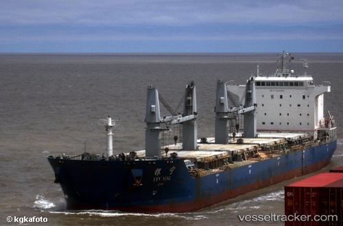
Yin Ning
Current StatusWhere is the vessel?
Yin Ning is currently in 40 nm S of Hamtic, based on AIS data received about 14h ago.
Latest AIS update:
Current position: 10.03333° N, 121.99333° E (40 nm S of Hamtic)
Average speed (last 7 days): Loading…
Average speed (last 30 days): Loading…
Vessel profile: Yin Ning is a Bulk Carrier with dimensions 32m x 190m.
This page combines live AIS, route history, probable destination signals, nearby traffic, and port activity for practical vessel monitoring.
The current position of vessel Yin Ning is 10.03333 lat / 121.99333 lng. Updated: 2026-05-19 16:26:29 UTCNearest reference points:
- Near Iloilo
- Near BACOLOD
- 17 nm SW of Bacong
Details:
Live Vessel Yin Ning Analytics (details, animations, etc.)
Recent AIS points (UTC):
2026-05-19 13:01:15 UTC · 9.49352, 122.31443 · SOG 11.1 kn · COG 315°2026-05-19 14:00:21 UTC · 9.62877, 122.18828 · SOG 11 kn · COG 319°
2026-05-19 16:26:29 UTC · 10.03333, 121.99333 · SOG 10 kn · COG -1°
2026-05-19 16:26:29 UTC · 10.03333, 121.99333 · SOG 10 kn · COG -1°