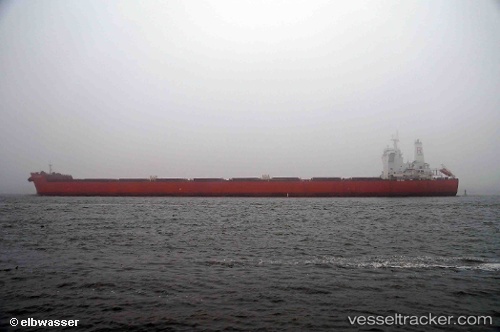
.
Vessel photo of Colossus (IMO 9398709) vesseltracker.com

Colossus

Vessel type: Bulk Carrier | IMO: 9398709 | MMSI: MMSI: 235074593
Call sign: 2COY6 | Dimensions: 45 m x 287 m
Current Status

Where is the vessel?

Colossus is currently in 19 nm SE of Cornwall, based on AIS data received about 1h ago.

Latest AIS update:

Current position: 49.90232° N, 3.71667° W (19 nm SE of Cornwall)

Average speed (last 7 days): Loading…

Average speed (last 30 days): Loading…

Vessel profile: Colossus is a Bulk Carrier with dimensions 45m x 287m.

This page combines live AIS, route history, probable destination signals, nearby traffic, and port activity for practical vessel monitoring.

The current position of vessel Colossus is 49.90232 lat / -3.71667 lng. Updated: 2026-04-18 03:33:39 UTC
Nearest reference points:
  • 27 nm N of Verzy
  • 12 nm S of Cornwall
  • Near Dartmouth
Details:

Live Vessel Colossus Analytics (details, animations, etc.)


Recent AIS points (UTC):
2026-04-17 22:18:06 UTC · 50.07639, -2.38356 · SOG 10.6 kn · COG 256°
2026-04-17 23:22:17 UTC · 50.02549, -2.69456 · SOG 11 kn · COG 256°
2026-04-18 01:23:20 UTC · 49.95657, -3.21582 · SOG 10.1 kn · COG 263°
2026-04-18 03:33:39 UTC · 49.90232, -3.71667 · SOG 7.7 kn · COG 263°

Track of the vessel in the last 60 days


UTC: --
Start: -- Track timeline (UTC) End: --
Encountered: --


Link to the map:


Find another ship

Colossus (235074593) last ports (portcalls and passsages)

PULAU SAMBU | 2025-08-04 16:02:41
TANAH MERAH | 2025-08-03 17:05:59
PENGERANG | 2025-08-03 15:52:59
PYEONGTAEK | 2025-05-05 01:58:24
BATU AMPAR | 2025-04-17 01:32:34
TANAH MERAH | 2025-04-16 15:28:49
PULAU SAMBU | 2025-04-16 13:11:19
BUKOM ISLAND | 2025-04-16 12:09:57
Saldanha Bay | 2025-03-21 07:15:46
SALDANHA | 2025-03-17 07:43:27
Saldanha Bay | 2025-03-17 07:15:37
Fateh Terminal | 2025-02-21 12:21:25
MUHARRAQ | 2025-02-17 04:48:02
SITRAH | 2025-02-17 04:17:22
KHALIFA BIN SALMAN | 2025-02-16 23:07:52
Port Elizabeth | 2025-01-21 12:25:32
Port Elizabeth | 2024-12-16 06:34:20
Sitrah Anchorage | 2024-11-11 02:56:34
HIDD | 2024-11-11 01:50:00
MUHARRAQ | 2024-11-09 20:09:01
SITRAH | 2024-11-09 05:54:09
Sitrah Anchorage | 2024-11-07 02:03:12
HIDD | 2024-11-07 00:54:55
Cape Of Good Hope | 2024-08-27 19:45:12
Sambu | 2024-06-29 07:23:59
Selat Sunda | 2024-06-21 07:54:25
Port Headland | 2024-06-15 00:34:16
Taicang | 2024-05-30 12:22:47
Wusong | 2024-05-30 10:13:23
Jingjiang | 2024-05-30 04:23:56
Singapore | 2024-05-16 00:32:30
Port Louis | 2024-04-28 04:44:38
Fujairah | 2024-02-28 06:16:58
Sitrah Anchorage | 2024-02-14 13:57:11
Sitrah Anchorage | 2024-02-06 11:28:20
Sitrah Anchorage | 2024-01-26 09:02:51
Fujairah | 2024-01-13 08:01:07
Sitrah Anchorage | 2024-01-05 16:42:01
Jubail | 2024-01-01 17:12:26
Sitrah Anchorage | 2023-12-24 13:24:59
Sitrah Anchorage | 2023-12-15 12:38:22
Sitrah Anchorage | 2023-11-24 10:25:05
Sitrah Anchorage | 2023-11-16 02:32:56
Sitrah Anchorage | 2023-11-07 19:33:35
Sitrah Anchorage | 2023-11-03 19:31:53
Cape Of Good Hope | 2023-09-10 05:55:07
Singapore | 2023-08-02 12:37:12
Gladstone Harbor | 2023-07-12 06:39:19
Newcastle | 2023-05-16 12:23:02
Taku Bar | 2023-04-15 01:03:50
Dagu Bar | 2023-04-13 01:05:27
Port Headland | 2023-03-19 00:09:18
Singapore | 2023-03-07 17:37:38
Newcastle | 2023-01-30 03:00:19
Taicang | 2023-01-16 08:10:47
Port Headland | 2022-12-15 09:08:29
Selat Lombok | 2022-12-09 08:30:59
Gemalink | 2022-12-02 12:02:35
Gemalink | 2022-11-28 11:16:32
Gemalink | 2022-11-24 08:59:46
Wusong | 2022-10-02 19:59:38
Port Headland | 2022-09-10 19:43:13
Newcastle | 2022-07-29 01:25:07
Wusong | 2022-06-23 13:04:16
Taku Bar | 2022-06-20 13:17:27
Dagu Bar | 2022-06-18 19:23:44
Port Headland | 2022-05-31 13:18:44
Selat Lombok | 2022-04-13 21:06:43
Port Headland | 2022-04-09 00:00:37
Selat Lombok | 2022-03-29 11:41:38
Vung Tau | 2022-02-06 06:25:09
Gemalink | 2022-01-29 08:00:12
Newcastle | 2022-01-08 04:35:51