 vesseltracker.com
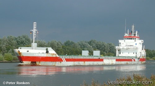
 Loireborg
Current Status
Where is the vessel?
Loireborg is currently in 22 nm W of PENICHE, based on AIS data received less than 1h ago.
Latest AIS update:
Current position: 39.32667° N, 9.84333° W (22 nm W of PENICHE)
Average speed (last 7 days): Loading…
Average speed (last 30 days): Loading…
Vessel profile: Loireborg is a Multi Purpose Carrier with dimensions 123m x 14m.
This page combines live AIS, route history, probable destination signals, nearby traffic, and port activity for practical vessel monitoring.
The current position of vessel Loireborg is 39.32667 lat / -9.84333 lng. Updated: 2026-05-14 04:10:11 UTCNearest reference points:
- Near PENICHE
- 18 nm W of Colares
- Near CASCAIS
Currently sailing under the flag of Netherlands ![]()
Loireborg built in 2008 year
Deadweight:
7350 tDetails:
Live Vessel Loireborg Analytics (details, animations, etc.)
Recent AIS points (UTC):
2026-05-14 01:35:45 UTC · 38.92304, -9.85938 · SOG 9.2 kn · COG 2°2026-05-14 01:50:35 UTC · 38.96167, -9.85843 · SOG 9.4 kn · COG 3°
2026-05-14 03:23:15 UTC · 39.20498, -9.84632 · SOG 9.2 kn · COG 2°
2026-05-14 04:10:11 UTC · 39.32667, -9.84333 · SOG 9 kn · COG -1°