 TRUE CHAMPION
Current Status
Where is the vessel?
TRUE CHAMPION is currently in Near TANAH MERAH, based on AIS data received about 15h ago.
Latest AIS update:
Current position: 1.28083° N, 104.02464° E (Near TANAH MERAH)
Average speed (last 7 days): Loading…
Average speed (last 30 days): Loading…
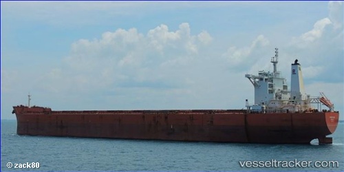
Vessel profile: TRUE CHAMPION is a Bulk Carrier with dimensions 45m x 292m.
This page combines live AIS, route history, probable destination signals, nearby traffic, and port activity for practical vessel monitoring.
The current position of vessel TRUE CHAMPION is 1.28083 lat / 104.02464 lng. Updated: 2026-05-21 13:47:56 UTCNearest reference points:
- Near TANAH MERAH
- Near Changi
- Near Tampines
Currently sailing under the flag of Liberia ![]()
TRUE CHAMPION built in 2011 year
Deadweight:
179156 tDetails:
Live Vessel TRUE CHAMPION Analytics (details, animations, etc.)
Recent AIS points (UTC):
2026-05-21 10:11:57 UTC · 1.28089, 104.02477 · SOG 0.1 kn · COG 91°2026-05-21 12:11:57 UTC · 1.28083, 104.02470 · SOG 0 kn · COG 89°
2026-05-21 13:29:55 UTC · 1.28096, 104.02445 · SOG 0 kn · COG 85°
2026-05-21 13:47:56 UTC · 1.28083, 104.02464 · SOG 0 kn · COG 87°