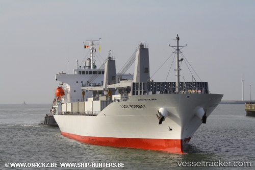
 Lady Rosebay
Current Status
Where is the vessel?
Lady Rosebay is currently in Near DICT / SVT, based on AIS data received about 14h ago.
Latest AIS update:
Current position: 7.20792° N, 125.65258° E (Near DICT / SVT)
Average speed (last 7 days): Loading…
Average speed (last 30 days): Loading…
Vessel profile: Lady Rosebay is a Refrigerated Cargo Ship with dimensions 143m x 23m.
This page combines live AIS, route history, probable destination signals, nearby traffic, and port activity for practical vessel monitoring.
The current position of vessel Lady Rosebay is 7.20792 lat / 125.65258 lng. Updated: 2026-07-02 07:46:15 UTCNearest reference points:
- Near DICT / SVT
- Near Taganito
- 48 nm N of Melonguanne
Currently sailing under the flag of Panama ![]()
Lady Rosebay built in 2010 year
Deadweight:
10601 tDetails:
Live Vessel Lady Rosebay Analytics (details, animations, etc.)
Recent AIS points (UTC):
2026-07-02 04:22:15 UTC · 7.20790, 125.65255 · SOG 0 kn · COG 352°2026-07-02 06:04:15 UTC · 7.20792, 125.65257 · SOG 0 kn · COG 352°
2026-07-02 07:22:15 UTC · 7.20792, 125.65257 · SOG 0 kn · COG 351°
2026-07-02 07:46:15 UTC · 7.20792, 125.65258 · SOG 0 kn · COG 351°