 vesseltracker.com
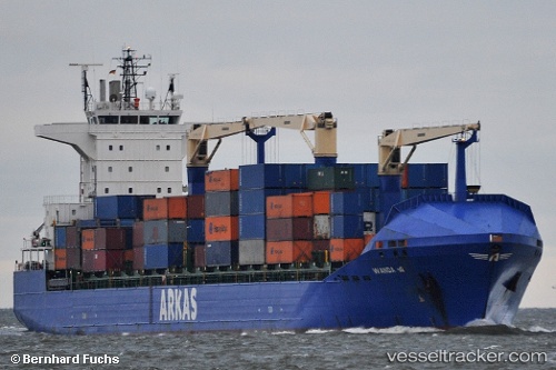
 WANDA A
Current Status
Where is the vessel?
WANDA A is currently in Near RUMELI FENERI, based on AIS data received about 1h ago.
Latest AIS update:
Current position: 41.27846° N, 28.99242° E (Near RUMELI FENERI)
Average speed (last 7 days): Loading…
Average speed (last 30 days): Loading…
Vessel profile: WANDA A is a Container Ship with dimensions 184m x 184m.
This page combines live AIS, route history, probable destination signals, nearby traffic, and port activity for practical vessel monitoring.
The current position of vessel WANDA A is 41.27846 lat / 28.99242 lng. Updated: 2026-05-14 06:51:17 UTCNearest reference points:
- Near RUMELI FENERI
- Near Istinye/Istambul
- Near Arnavutköy/Istambul
Currently sailing under the flag of Malta ![]()
WANDA A built in 2009 year
Deadweight:
21990 tDetails:
Live Vessel WANDA A Analytics (details, animations, etc.)
Recent AIS points (UTC):
2026-05-14 05:07:56 UTC · 41.35108, 29.25971 · SOG 11.6 kn · COG 267°2026-05-14 06:00:45 UTC · 41.31109, 29.04420 · SOG 11.5 kn · COG 236°
2026-05-14 06:51:17 UTC · 41.27846, 28.99242 · SOG 0.1 kn · COG 32°
2026-05-14 06:51:17 UTC · 41.27846, 28.99242 · SOG 0.1 kn · COG 32°