 Deltagracht
Current Status
Where is the vessel?
Deltagracht is currently in 33 nm N of Nedroma, based on AIS data received about 14h ago.
Latest AIS update:
Current position: 35.54148° N, 14.81611° W (33 nm N of Nedroma)
Average speed (last 7 days): Loading…
Average speed (last 30 days): Loading…
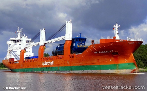
Vessel profile: Deltagracht is a General Cargo Ship with dimensions 157m x 23m.
This page combines live AIS, route history, probable destination signals, nearby traffic, and port activity for practical vessel monitoring.
The current position of vessel Deltagracht is 35.54148 lat / -14.81611 lng. Updated: 2026-06-23 14:00:43 UTCNearest reference points:
- 75 nm NE of Nedroma
- 78 nm W of Nedroma
- 74 nm E of Alozaina
Currently sailing under the flag of Netherlands ![]()
Deltagracht built in 2009 year
Deadweight:
18143 tDetails:
Live Vessel Deltagracht Analytics (details, animations, etc.)
Recent AIS points (UTC):
2026-06-23 10:56:13 UTC · 35.57500, -13.95333 · SOG 13 kn · COG -1°2026-06-23 11:14:13 UTC · 35.57167, -14.03500 · SOG 13 kn · COG -1°
2026-06-23 13:56:15 UTC · 35.54167, -14.79500 · SOG 13 kn · COG -1°
2026-06-23 14:00:43 UTC · 35.54148, -14.81611 · SOG 13.5 kn · COG 267°