 BG RUBY
Current Status
Where is the vessel?
BG RUBY is currently in Near Pornichet, based on AIS data received about 16h ago.
Latest AIS update:
Current position: 47.12266° N, 2.42662° W (Near Pornichet)
Average speed (last 7 days): Loading…
Average speed (last 30 days): Loading…
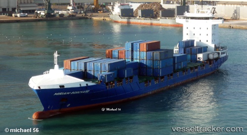
Vessel profile: BG RUBY is a Container Ship with dimensions 141m x 22m.
This page combines live AIS, route history, probable destination signals, nearby traffic, and port activity for practical vessel monitoring.
The current position of vessel BG RUBY is 47.12266 lat / -2.42662 lng. Updated: 2026-06-17 10:13:28 UTCNearest reference points:
- 12 nm S of Saint-Céols
- 13 nm S of Saint-Céols
- Near LE CROISIC
Currently sailing under the flag of Portugal (MAR) ![]()
BG RUBY built in 2010 year
Deadweight:
9300 tDetails:
Live Vessel BG RUBY Analytics (details, animations, etc.)
Recent AIS points (UTC):
2026-06-17 07:37:53 UTC · 47.12262, -2.42460 · SOG 0.7 kn · COG 59°2026-06-17 08:34:19 UTC · 47.12183, -2.42593 · SOG 0.2 kn · COG 27°
2026-06-17 09:58:28 UTC · 47.12257, -2.42670 · SOG 0.1 kn · COG 77°
2026-06-17 10:13:28 UTC · 47.12266, -2.42662 · SOG 0.1 kn · COG 96°