 Halland
Current Status
Where is the vessel?
Halland is currently in Near Sereetz, based on AIS data received about 14h ago.
Latest AIS update:
Current position: 53.89729° N, 10.80507° E (Near Sereetz)
Average speed (last 7 days): Loading…
Average speed (last 30 days): Loading…
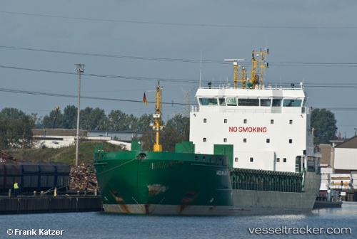
Vessel profile: Halland is a Multi Purpose Carrier with dimensions 119m x 16m.
This page combines live AIS, route history, probable destination signals, nearby traffic, and port activity for practical vessel monitoring.
The current position of vessel Halland is 53.89729 lat / 10.80507 lng. Updated: 2026-05-20 13:24:47 UTCNearest reference points:
- Near NIENDORFER
- Near Sereetz
- Near Lubeck
Currently sailing under the flag of Cyprus ![]()
Halland built in 2008 year
Deadweight:
6795 tDetails:
Live Vessel Halland Analytics (details, animations, etc.)
Recent AIS points (UTC):
2026-05-20 09:36:46 UTC · 53.89663, 10.80673 · SOG 0 kn · COG 124°2026-05-20 10:24:47 UTC · 53.89665, 10.80672 · SOG 0 kn · COG 125°
2026-05-20 11:48:47 UTC · 53.89663, 10.80671 · SOG 0 kn · COG 124°
2026-05-20 13:24:47 UTC · 53.89729, 10.80507 · SOG 0 kn · COG 125°