 TORM NEW ZEALAND
Current Status
Where is the vessel?
TORM NEW ZEALAND is currently in 114 nm SE of Wenling Longmen Port, based on AIS data received about 15h ago.
Latest AIS update:
Current position: 27.08845° N, 123.50334° E (114 nm SE of Wenling Longmen Port)
Average speed (last 7 days): Loading…
Average speed (last 30 days): Loading…
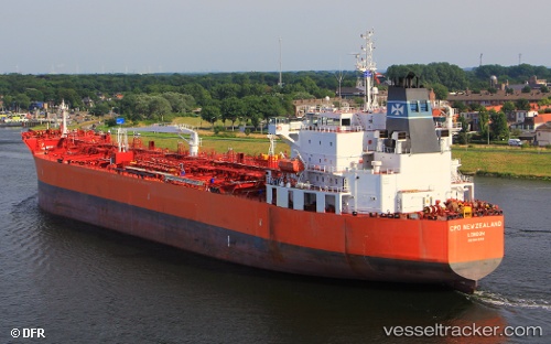
Vessel profile: TORM NEW ZEALAND is a Chemical/Oil Products Tanker with dimensions 183m x 32m.
This page combines live AIS, route history, probable destination signals, nearby traffic, and port activity for practical vessel monitoring.
The current position of vessel TORM NEW ZEALAND is 27.08845 lat / 123.50334 lng. Updated: 2026-06-23 19:41:08 UTCNearest reference points:
- 97 nm SE of Wenling Longmen Port
- 120 nm NE of Nangang
- 76 nm NE of Nangang
Currently sailing under the flag of Denmark (DIS) ![]()
TORM NEW ZEALAND built in 2011 year
Deadweight:
49999 tDetails:
Live Vessel TORM NEW ZEALAND Analytics (details, animations, etc.)
Recent AIS points (UTC):
2026-06-23 16:00:26 UTC · 26.20423, 123.04754 · SOG 15.3 kn · COG 26°2026-06-23 18:23:01 UTC · 26.79167, 123.29667 · SOG 16 kn · COG -1°
2026-06-23 19:39:45 UTC · 27.08324, 123.49943 · SOG 16 kn · COG 35°
2026-06-23 19:41:08 UTC · 27.08845, 123.50334 · SOG 15.9 kn · COG 35°