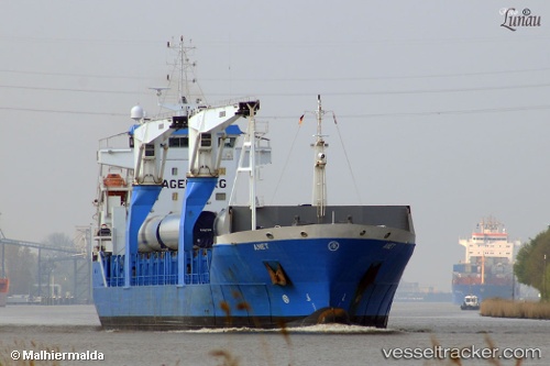
Anet
Current StatusWhere is the vessel?
Anet is currently in Near MAASVLAKTE - ROTTERDAM, based on AIS data received about 15h ago.
Latest AIS update:
Current position: 51.96135° N, 4.04668° E (Near MAASVLAKTE - ROTTERDAM)
Average speed (last 7 days): Loading…
Average speed (last 30 days): Loading…
Vessel profile: Anet is a Multi Purpose Carrier with dimensions 19m x 143m.
This page combines live AIS, route history, probable destination signals, nearby traffic, and port activity for practical vessel monitoring.
The current position of vessel Anet is 51.96135 lat / 4.04668 lng. Updated: 2026-07-13 13:53:35 UTCNearest reference points:
- Near MAASVLAKTE - ROTTERDAM
- Near HOEK VAN HOLLAND
- Near Haarlemmermeer
Details:
Live Vessel Anet Analytics (details, animations, etc.)
Recent AIS points (UTC):
2026-07-13 10:56:27 UTC · 51.96134, 4.04668 · SOG 0 kn · COG 82°2026-07-13 11:17:28 UTC · 51.96134, 4.04666 · SOG 0 kn · COG 82°
2026-07-13 13:14:28 UTC · 51.96137, 4.04669 · SOG 0 kn · COG 83°
2026-07-13 13:53:35 UTC · 51.96135, 4.04668 · SOG 0 kn · COG 81°