 Merkur Archipelago
Current Status
Where is the vessel?
Merkur Archipelago is currently in 30 nm S of Nam Hai Dinh Vu Port, based on AIS data received about 14h ago.
Latest AIS update:
Current position: 20.35500° N, 107.04333° E (30 nm S of Nam Hai Dinh Vu Port)
Average speed (last 7 days): Loading…
Average speed (last 30 days): Loading…
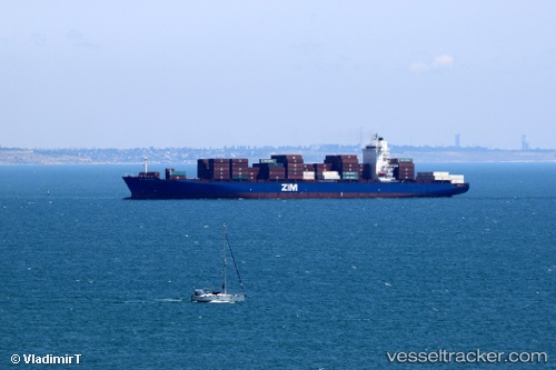
Vessel profile: Merkur Archipelago is a Container Ship with dimensions 262m x 32m.
This page combines live AIS, route history, probable destination signals, nearby traffic, and port activity for practical vessel monitoring.
The current position of vessel Merkur Archipelago is 20.35500 lat / 107.04333 lng. Updated: 2026-05-21 17:47:12 UTCNearest reference points:
- 25 nm S of Nam Hai Dinh Vu Port
- 12 nm SE of Nam Hai Dinh Vu Port
- 14 nm SE of Nam Hai Dinh Vu Port
Currently sailing under the flag of Liberia ![]()
Merkur Archipelago built in 2009 year
Deadweight:
51534 tDetails:
Live Vessel Merkur Archipelago Analytics (details, animations, etc.)
Recent AIS points (UTC):
2026-05-21 13:51:03 UTC · 20.78802, 106.91569 · SOG 0.5 kn · COG 329°2026-05-21 16:06:32 UTC · 20.62642, 106.89692 · SOG 5 kn · COG 227°
2026-05-21 16:07:50 UTC · 20.62522, 106.89547 · SOG 5 kn · COG 198°
2026-05-21 17:47:12 UTC · 20.35500, 107.04333 · SOG 12 kn · COG -1°