 vesseltracker.com
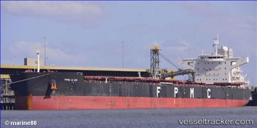
 SEA ROSE
Current Status
Where is the vessel?
SEA ROSE is currently in Near TANJUNG PEMANCINGAN, based on AIS data received about 14h ago.
Latest AIS update:
Current position: 3.16500° S, 116.38833° E (Near TANJUNG PEMANCINGAN)
Average speed (last 7 days): Loading…
Average speed (last 30 days): Loading…
Vessel profile: SEA ROSE is a Bulk Carrier with dimensions m x m.
This page combines live AIS, route history, probable destination signals, nearby traffic, and port activity for practical vessel monitoring.
The current position of vessel SEA ROSE is -3.16500 lat / 116.38833 lng. Updated: 2026-05-18 06:53:09 UTCNearest reference points:
- Near TANJUNG PEMANCINGAN
- 57 nm NE of TANJUNG PEMANCINGAN
- 12 nm SE of Bunati
Currently sailing under the flag of Indonesia ![]()
Details:
Live Vessel SEA ROSE Analytics (details, animations, etc.)
Recent AIS points (UTC):
2026-05-18 03:06:34 UTC · -3.16740, 116.39106 · SOG 0 kn · COG 270°2026-05-18 03:42:36 UTC · -3.16783, 116.39103 · SOG 0 kn · COG 280°
2026-05-18 06:14:05 UTC · -3.16500, 116.38833 · SOG 0 kn · COG -1°
2026-05-18 06:53:09 UTC · -3.16500, 116.38833 · SOG 0 kn · COG -1°