 vesseltracker.com
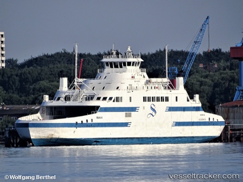
 KAMUTIK W
Current Status
Where is the vessel?
KAMUTIK W is currently in Near Conception Bay South, based on AIS data received less than 1h ago.
Latest AIS update:
Current position: 47.62977° N, 52.92394° W (Near Conception Bay South)
Average speed (last 7 days): Loading…
Average speed (last 30 days): Loading…
Vessel profile: KAMUTIK W is a Passenger/Ro-Ro Ship (vehicles) with dimensions 18m x 98m.
This page combines live AIS, route history, probable destination signals, nearby traffic, and port activity for practical vessel monitoring.
The current position of vessel KAMUTIK W is 47.62977 lat / -52.92394 lng. Updated: 2026-05-15 05:41:23 UTCNearest reference points:
- Near St. John’S
- Near Witless Bay
- Near Catalina
Currently sailing under the flag of Canada ![]()
KAMUTIK W built in 2011 year
Deadweight:
900 tDetails:
Live Vessel KAMUTIK W Analytics (details, animations, etc.)
Recent AIS points (UTC):
2026-05-15 01:26:23 UTC · 47.62976, -52.92394 · SOG 0 kn · COG 12°2026-05-15 04:11:23 UTC · 47.62975, -52.92396 · SOG 0 kn · COG 12°
2026-05-15 04:20:22 UTC · 47.62974, -52.92394 · SOG 0 kn · COG 12°
2026-05-15 05:41:23 UTC · 47.62977, -52.92394 · SOG 0 kn · COG 11°