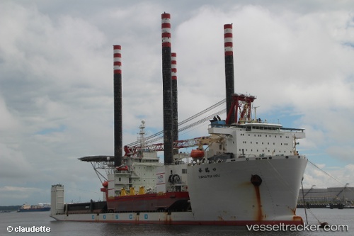
 Xiang Rui Kou
Current Status
Where is the vessel?
Xiang Rui Kou is currently in 203 nm W of Bolinao, based on AIS data received about 14h ago.
Latest AIS update:
Current position: 15.67500° N, 116.44833° E (203 nm W of Bolinao)
Average speed (last 7 days): Loading…
Average speed (last 30 days): Loading…
Vessel profile: Xiang Rui Kou is a Heavy Load Carrier with dimensions 217m x 43m.
This page combines live AIS, route history, probable destination signals, nearby traffic, and port activity for practical vessel monitoring.
The current position of vessel Xiang Rui Kou is 15.67500 lat / 116.44833 lng. Updated: 2026-06-13 10:54:43 UTCNearest reference points:
- 222 nm W of Iba
- 138 nm NW of Bolinao
- 282 nm E of Tan Cang Qui Nhon
Currently sailing under the flag of China ![]()
Xiang Rui Kou built in 2011 year
Deadweight:
48293 tDetails:
Live Vessel Xiang Rui Kou Analytics (details, animations, etc.)
Recent AIS points (UTC):
2026-06-13 07:18:37 UTC · 15.18500, 116.99167 · SOG 10 kn · COG -1°2026-06-13 07:24:35 UTC · 15.19667, 116.97833 · SOG 10 kn · COG -1°
2026-06-13 09:33:59 UTC · 15.49339, 116.65784 · SOG 12.1 kn · COG -1°
2026-06-13 10:54:43 UTC · 15.67500, 116.44833 · SOG 12 kn · COG -1°