 vesseltracker.com
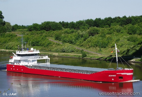
 Adamas
Current Status
Where is the vessel?
Adamas is currently in 13 nm S of Kallviken, based on AIS data received less than 1h ago.
Latest AIS update:
Current position: 60.16653° N, 26.32571° E (13 nm S of Kallviken)
Average speed (last 7 days): Loading…
Average speed (last 30 days): Loading…
Vessel profile: Adamas is a General Cargo Ship with dimensions 83m x 13m.
This page combines live AIS, route history, probable destination signals, nearby traffic, and port activity for practical vessel monitoring.
The current position of vessel Adamas is 60.16653 lat / 26.32571 lng. Updated: 2026-05-14 10:06:50 UTCNearest reference points:
- Near Vessölandet
- 13 nm N of Viinistu Sadam
- Near Lakulahti
Currently sailing under the flag of Netherlands ![]()
Adamas built in 2010 year
Deadweight:
3750 tDetails:
Live Vessel Adamas Analytics (details, animations, etc.)
Recent AIS points (UTC):
2026-05-14 07:23:30 UTC · 60.41905, 26.90131 · SOG 1 kn · COG 268°2026-05-14 07:28:31 UTC · 60.41691, 26.90253 · SOG 4.8 kn · COG 149°
2026-05-14 09:36:21 UTC · 60.23158, 26.40810 · SOG 9 kn · COG 205°
2026-05-14 10:06:50 UTC · 60.16653, 26.32571 · SOG 9.2 kn · COG 223°