 Redhook
Current Status
Where is the vessel?
Redhook is currently in Near Hunts Point/Bronx/New York, based on AIS data received about 14h ago.
Latest AIS update:
Current position: 40.80185° N, 73.88429° W (Near Hunts Point/Bronx/New York)
Average speed (last 7 days): Loading…
Average speed (last 30 days): Loading…
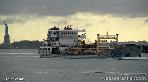
Vessel profile: Redhook is a Waste Disposal Vessel with dimensions 106m x 15m.
This page combines live AIS, route history, probable destination signals, nearby traffic, and port activity for practical vessel monitoring.
The current position of vessel Redhook is 40.80185 lat / -73.88429 lng. Updated: 2026-06-10 23:37:58 UTCNearest reference points:
- Near Williamsburg/Brooklyn/New York
- Near Hoboken
- Near New York
Currently sailing under the flag of USA ![]()
Redhook built in 2008 year
Deadweight:
4371 tDetails:
Live Vessel Redhook Analytics (details, animations, etc.)
Recent AIS points (UTC):
2026-06-10 20:20:58 UTC · 40.79865, -73.83795 · SOG 0 kn · COG 253°2026-06-10 21:24:28 UTC · 40.79866, -73.83794 · SOG 0.2 kn · COG 254°
2026-06-10 23:24:36 UTC · 40.80197, -73.88427 · SOG 0.1 kn · COG 286°
2026-06-10 23:37:58 UTC · 40.80185, -73.88429 · SOG 0.1 kn · COG 288°