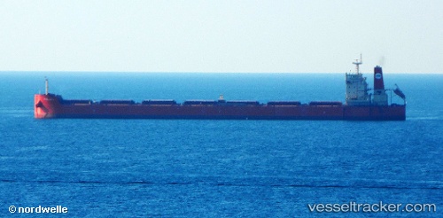
Pan Bona
Current StatusWhere is the vessel?
Pan Bona is currently in 23 nm S of Kukdo, based on AIS data received about 14h ago.
Latest AIS update:
Current position: 34.17094° N, 128.27991° E (23 nm S of Kukdo)
Average speed (last 7 days): Loading…
Average speed (last 30 days): Loading…
Vessel profile: Pan Bona is a Bulk Carrier with dimensions 45m x 292m.
This page combines live AIS, route history, probable destination signals, nearby traffic, and port activity for practical vessel monitoring.
The current position of vessel Pan Bona is 34.17094 lat / 128.27991 lng. Updated: 2026-05-23 00:02:57 UTCNearest reference points:
- 25 nm S of Kukdo
- 15 nm S of Kukdo
- 35 nm E of Geomundo
Details:
Live Vessel Pan Bona Analytics (details, animations, etc.)
Recent AIS points (UTC):
2026-05-22 20:02:57 UTC · 34.17106, 128.27837 · SOG 0.3 kn · COG 54°2026-05-22 22:13:07 UTC · 34.17066, 128.28004 · SOG 0.1 kn · COG -1°
2026-05-22 22:47:57 UTC · 34.17040, 128.27997 · SOG 0 kn · COG 6°
2026-05-23 00:02:57 UTC · 34.17094, 128.27991 · SOG 0.2 kn · COG 357°