 ANNIKA N
Current Status
Where is the vessel?
ANNIKA N is currently in Near Pasadena, based on AIS data received about 15h ago.
Latest AIS update:
Current position: 29.72108° N, 95.23900° W (Near Pasadena)
Average speed (last 7 days): Loading…
Average speed (last 30 days): Loading…
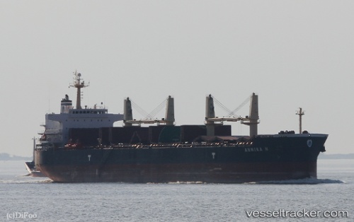
Vessel profile: ANNIKA N is a Bulk Carrier with dimensions 190m x 33m.
This page combines live AIS, route history, probable destination signals, nearby traffic, and port activity for practical vessel monitoring.
The current position of vessel ANNIKA N is 29.72108 lat / -95.23900 lng. Updated: 2026-06-17 13:45:24 UTCNearest reference points:
- Near Pasadena
- Near Jacinto City
- Near Morgan Point
Currently sailing under the flag of Marshall Islands ![]()
ANNIKA N built in 2011 year
Deadweight:
55768 tDetails:
Live Vessel ANNIKA N Analytics (details, animations, etc.)
Recent AIS points (UTC):
2026-06-17 10:24:25 UTC · 29.72113, -95.23915 · SOG 0 kn · COG 248°2026-06-17 12:27:25 UTC · 29.72108, -95.23910 · SOG 0 kn · COG 248°
2026-06-17 13:24:24 UTC · 29.72117, -95.23908 · SOG 0 kn · COG 248°
2026-06-17 13:45:24 UTC · 29.72108, -95.23900 · SOG 0 kn · COG 248°