 vesseltracker.com
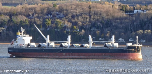
 BULK VALOR
Current Status
Where is the vessel?
BULK VALOR is currently in Near Norfolk, based on AIS data received about 1h ago.
Latest AIS update:
Current position: 36.87985° N, 76.33108° W (Near Norfolk)
Average speed (last 7 days): Loading…
Average speed (last 30 days): Loading…
Vessel profile: BULK VALOR is a Bulk Carrier with dimensions 32m x 190m.
This page combines live AIS, route history, probable destination signals, nearby traffic, and port activity for practical vessel monitoring.
The current position of vessel BULK VALOR is 36.87985 lat / -76.33108 lng. Updated: 2026-05-13 19:44:06 UTCNearest reference points:
- Near Norfolk
- Near Sewell's Point
- Near Hampton Roads Pt
Currently sailing under the flag of Panama ![]()
BULK VALOR built in 2013 year
Deadweight:
58105 tDetails:
Live Vessel BULK VALOR Analytics (details, animations, etc.)
Recent AIS points (UTC):
2026-05-13 16:17:03 UTC · 36.87989, -76.33110 · SOG 0.1 kn · COG 95°2026-05-13 17:56:04 UTC · 36.87989, -76.33110 · SOG 0.1 kn · COG 96°
2026-05-13 19:44:00 UTC · 36.87986, -76.33108 · SOG 0 kn · COG 96°
2026-05-13 19:44:06 UTC · 36.87985, -76.33108 · SOG 0 kn · COG 96°