 Timber Navigator
Current Status
Where is the vessel?
Timber Navigator is currently in Near Iroquois, based on AIS data received about 14h ago.
Latest AIS update:
Current position: 44.83056° N, 75.31279° W (Near Iroquois)
Average speed (last 7 days): Loading…
Average speed (last 30 days): Loading…
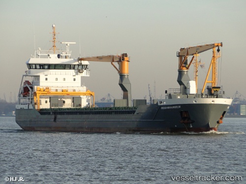
Vessel profile: Timber Navigator is a Multi Purpose Carrier with dimensions 118m x 16m.
This page combines live AIS, route history, probable destination signals, nearby traffic, and port activity for practical vessel monitoring.
The current position of vessel Timber Navigator is 44.83056 lat / -75.31279 lng. Updated: 2026-05-22 10:18:04 UTCNearest reference points:
- Near Montreal
- Near Longueuil
- Near Montréal-Est
Currently sailing under the flag of Netherlands ![]()
Timber Navigator built in 2011 year
Deadweight:
8270 tDetails:
Live Vessel Timber Navigator Analytics (details, animations, etc.)
Recent AIS points (UTC):
2026-05-22 07:26:23 UTC · 44.52593, -75.75576 · SOG 12 kn · COG 39°2026-05-22 07:51:34 UTC · 44.58435, -75.68039 · SOG 11.4 kn · COG 43°
2026-05-22 09:58:24 UTC · 44.82533, -75.31637 · SOG 1.8 kn · COG 26°
2026-05-22 10:18:04 UTC · 44.83056, -75.31279 · SOG 0 kn · COG 27°