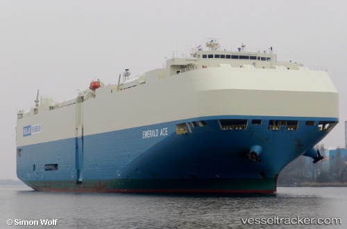
Emerald Ace
Current StatusWhere is the vessel?
Emerald Ace is currently in 18 nm S of Xewkija, based on AIS data received about 15h ago.
Latest AIS update:
Current position: 35.95049° N, 141.95200° E (18 nm S of Xewkija)
Average speed (last 7 days): Loading…
Average speed (last 30 days): Loading…
Vessel profile: Emerald Ace is a Vehicles Carrier with dimensions 32m x 200m.
This page combines live AIS, route history, probable destination signals, nearby traffic, and port activity for practical vessel monitoring.
The current position of vessel Emerald Ace is 35.95049 lat / 141.95200 lng. Updated: 2026-05-19 13:47:50 UTCNearest reference points:
- 12 nm E of CHOSHI
- 37 nm E of ONAHAMA
- Near KASHIMA
Details:
Live Vessel Emerald Ace Analytics (details, animations, etc.)
Recent AIS points (UTC):
2026-05-19 10:34:26 UTC · 35.96819, 142.66135 · SOG 11.3 kn · COG 262°2026-05-19 11:35:45 UTC · 35.96424, 142.42911 · SOG 11 kn · COG -1°
2026-05-19 13:47:50 UTC · 35.95049, 141.95200 · SOG 10.5 kn · COG -1°
2026-05-19 13:47:50 UTC · 35.95049, 141.95200 · SOG 10.5 kn · COG -1°