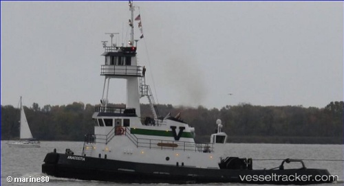
 Anacostia
Current Status
Where is the vessel?
Anacostia is currently in 22 nm SE of Port Bolivar, based on AIS data received about 15h ago.
Latest AIS update:
Current position: 29.18939° N, 94.38945° W (22 nm SE of Port Bolivar)
Average speed (last 7 days): Loading…
Average speed (last 30 days): Loading…
Vessel profile: Anacostia is a Pusher Tug with dimensions 33m x 33m.
This page combines live AIS, route history, probable destination signals, nearby traffic, and port activity for practical vessel monitoring.
The current position of vessel Anacostia is 29.18939 lat / -94.38945 lng. Updated: 2026-05-20 11:22:39 UTCNearest reference points:
- 12 nm SE of Port Bolivar
- 40 nm SE of Galveston
- 23 nm SW of Sabine Pass
Currently sailing under the flag of USA ![]()
Anacostia built in 2009 year
Deadweight:
364 tDetails:
Live Vessel Anacostia Analytics (details, animations, etc.)
Recent AIS points (UTC):
2026-05-20 08:11:20 UTC · 29.01865, -94.07395 · SOG 4.3 kn · COG 12°2026-05-20 10:03:01 UTC · 29.10015, -94.26364 · SOG 6.9 kn · COG 303°
2026-05-20 10:12:21 UTC · 29.11008, -94.28022 · SOG 6.8 kn · COG 302°
2026-05-20 11:22:39 UTC · 29.18939, -94.38945 · SOG 5.4 kn · COG 338°