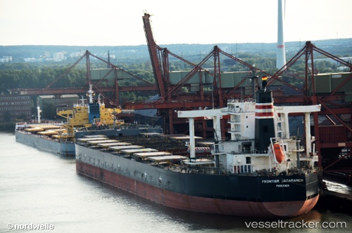
 FRONTIER JACARANDA
Current Status
Where is the vessel?
FRONTIER JACARANDA is currently in Near Port-Cartier, based on AIS data received about 118d ago.
Latest AIS update:
Current position: 50.03200° N, 66.78861° W (Near Port-Cartier)
Average speed (last 7 days): Loading…
Average speed (last 30 days): Loading…
Vessel profile: FRONTIER JACARANDA is a Bulk Carrier with dimensions 292m x 46m.
This page combines live AIS, route history, probable destination signals, nearby traffic, and port activity for practical vessel monitoring.
The current position of vessel FRONTIER JACARANDA is 50.03200 lat / -66.78861 lng. Updated: 2026-01-21 14:36:23 UTCNearest reference points:
- 22 nm N of Sainte-Anne-des-Monts
- 15 nm NW of Saint-Anaclet
Currently sailing under the flag of Japan ![]()
FRONTIER JACARANDA built in 2011 year
Deadweight:
182757 tDetails:
Live Vessel FRONTIER JACARANDA Analytics (details, animations, etc.)
Recent AIS points (UTC):
2026-01-21 14:36:23 UTC · 50.03200, -66.78861 · SOG 0 kn · COG 75°