Truongloc16
Current StatusWhere is the vessel?
Truongloc16 is currently in 86 nm NE of Pulau Lang Lang, based on AIS data received about 16h ago.
Latest AIS update:
Current position: 8.30918° N, 114.95078° E (86 nm NE of Pulau Lang Lang)
Average speed (last 7 days): Loading…
Average speed (last 30 days): Loading…
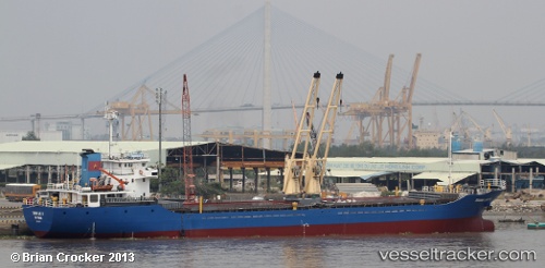
Vessel profile: Truongloc16 is a General Cargo Ship with dimensions 16m x 92m.
This page combines live AIS, route history, probable destination signals, nearby traffic, and port activity for practical vessel monitoring.
The current position of vessel Truongloc16 is 8.30918 lat / 114.95078 lng. Updated: 2026-05-19 00:01:33 UTCNearest reference points:
- 159 nm N of Pulau Lang Lang
- 44 nm SW of Tembungo
- 175 nm N of Pulau Lang Lang
Details:
Live Vessel Truongloc16 Analytics (details, animations, etc.)
Recent AIS points (UTC):
2026-05-18 22:19:54 UTC · 8.34505, 114.73928 · SOG 7 kn · COG 103°2026-05-19 00:01:33 UTC · 8.30918, 114.95078 · SOG 7 kn · COG 92°
2026-05-19 00:01:33 UTC · 8.30918, 114.95078 · SOG 7 kn · COG 92°
2026-05-19 00:01:33 UTC · 8.30918, 114.95078 · SOG 7 kn · COG 92°