 Algoma Mariner
Current Status
Where is the vessel?
Algoma Mariner is currently in Near Veracruz, based on AIS data received about 14h ago.
Latest AIS update:
Current position: 19.20952° N, 96.12536° W (Near Veracruz)
Average speed (last 7 days): Loading…
Average speed (last 30 days): Loading…
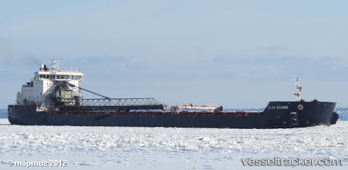
Vessel profile: Algoma Mariner is a Self Discharging Bulk Carrier with dimensions 225m x 225m.
This page combines live AIS, route history, probable destination signals, nearby traffic, and port activity for practical vessel monitoring.
The current position of vessel Algoma Mariner is 19.20952 lat / -96.12536 lng. Updated: 2026-05-19 16:27:48 UTCNearest reference points:
- Near Veracruz
- 25 nm E of Tuxpan
- Near Coatzacoalcos
Currently sailing under the flag of Canada ![]()
Algoma Mariner built in 2011 year
Deadweight:
37690 tDetails:
Live Vessel Algoma Mariner Analytics (details, animations, etc.)
Recent AIS points (UTC):
2026-05-19 13:39:49 UTC · 19.20952, -96.12535 · SOG 0 kn · COG 187°2026-05-19 13:39:49 UTC · 19.20952, -96.12535 · SOG 0 kn · COG 187°
2026-05-19 16:09:49 UTC · 19.20952, -96.12536 · SOG 0 kn · COG 187°
2026-05-19 16:27:48 UTC · 19.20952, -96.12536 · SOG 0 kn · COG 187°