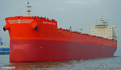
 Panther Max
Current Status
Where is the vessel?
Panther Max is currently in 30 nm NW of Roque De Los Muchachos, based on AIS data received about 14h ago.
Latest AIS update:
Current position: 29.15271° N, 18.21051° W (30 nm NW of Roque De Los Muchachos)
Average speed (last 7 days): Loading…
Average speed (last 30 days): Loading…
Vessel profile: Panther Max is a Bulk Carrier with dimensions 229m x 229m.
This page combines live AIS, route history, probable destination signals, nearby traffic, and port activity for practical vessel monitoring.
The current position of vessel Panther Max is 29.15271 lat / -18.21051 lng. Updated: 2026-07-31 12:03:10 UTCNearest reference points:
- Near Tazacorte
- Near Santa Cruz de La Palma
- Near Breña Baja
Currently sailing under the flag of Bahamas ![]()
Panther Max built in 2012 year
Deadweight:
81283 tDetails:
Live Vessel Panther Max Analytics (details, animations, etc.)
Recent AIS points (UTC):
2026-07-31 08:06:10 UTC · 29.04105, -17.31073 · SOG 12 kn · COG 276°2026-07-31 09:25:09 UTC · 29.07595, -17.61456 · SOG 11.9 kn · COG 277°
2026-07-31 10:18:39 UTC · 29.09736, -17.81376 · SOG 11.9 kn · COG 277°
2026-07-31 12:03:10 UTC · 29.15271, -18.21051 · SOG 12.1 kn · COG 276°