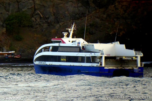
Liberdadi
Current StatusWhere is the vessel?
Liberdadi is currently in Near Praia, based on AIS data received about 14h ago.
Latest AIS update:
Current position: 14.91221° N, 23.50117° W (Near Praia)
Average speed (last 7 days): Loading…
Average speed (last 30 days): Loading…
Vessel profile: Liberdadi is a Passenger Ro Ro Cargo Ship with dimensions 10m x 45m.
This page combines live AIS, route history, probable destination signals, nearby traffic, and port activity for practical vessel monitoring.
The current position of vessel Liberdadi is 14.91221 lat / -23.50117 lng. Updated: 2026-05-20 16:00:01 UTCNearest reference points:
- 39 nm W of Ilha do Sal
- Near Ilha do Sal
Details:
Live Vessel Liberdadi Analytics (details, animations, etc.)
Recent AIS points (UTC):
2026-05-20 12:13:11 UTC · 15.02332, -23.33088 · SOG 18.2 kn · COG 208°2026-05-20 13:19:06 UTC · 14.91222, -23.50118 · SOG 0 kn · COG 295°
2026-05-20 14:17:23 UTC · 14.91222, -23.50118 · SOG 0 kn · COG 294°
2026-05-20 16:00:01 UTC · 14.91221, -23.50117 · SOG 0 kn · COG 295°