 NANTUCKET
Current Status
Where is the vessel?
NANTUCKET is currently in 154 nm SW of Baía dos Tigres, based on AIS data received about 14h ago.
Latest AIS update:
Current position: 18.88940° S, 10.52579° E (154 nm SW of Baía dos Tigres)
Average speed (last 7 days): Loading…
Average speed (last 30 days): Loading…
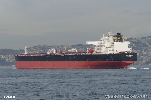
Vessel profile: NANTUCKET is a Crude Oil Tanker with dimensions 275m x 48m.
This page combines live AIS, route history, probable destination signals, nearby traffic, and port activity for practical vessel monitoring.
The current position of vessel NANTUCKET is -18.88940 lat / 10.52579 lng. Updated: 2026-05-20 09:36:44 UTCNearest reference points:
- 136 nm S of Baía dos Tigres
Currently sailing under the flag of Liberia ![]()
NANTUCKET built in 2014 year
Deadweight:
156902 tDetails:
Live Vessel NANTUCKET Analytics (details, animations, etc.)
Recent AIS points (UTC):
2026-05-20 06:02:53 UTC · -19.63667, 10.75667 · SOG 10 kn · COG -1°2026-05-20 07:41:50 UTC · -19.33500, 10.66167 · SOG 15 kn · COG -1°
2026-05-20 08:08:48 UTC · -19.22167, 10.62833 · SOG 15 kn · COG -1°
2026-05-20 09:36:44 UTC · -18.88940, 10.52579 · SOG 11.2 kn · COG 343°