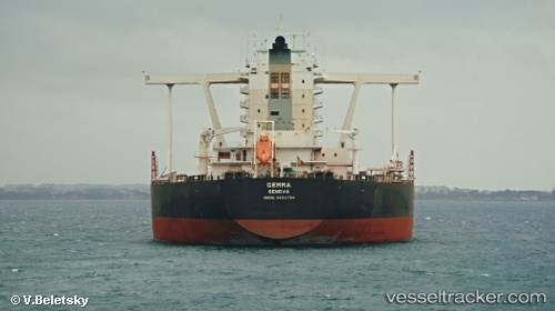
.

IT flag Gemma

Vessel type: Ore Carrier | IMO: 9602784 | MMSI: MMSI: 247302100
Call sign: ICPC | Dimensions: 330 m x 57 m
Current Status

Where is the vessel?

Gemma is currently in 101 nm NE of Tanjungbatu, based on AIS data received about 15h ago.

Latest AIS update:

Current position: 2.96500° N, 119.61667° E (101 nm NE of Tanjungbatu)

Average speed (last 7 days): Loading…

Average speed (last 30 days): Loading…

Vessel profile: Gemma is a Ore Carrier with dimensions 330m x 57m.

This page combines live AIS, route history, probable destination signals, nearby traffic, and port activity for practical vessel monitoring.

The current position of vessel Gemma is 2.96500 lat / 119.61667 lng. Updated: 2026-05-20 07:48:19 UTC
More recent position available: 55 min ago
Free positions are delayed by 14 hours.

We recommend registering. If you register, paid vessel access will be saved in your profile. Guest access works only through a personal link.

Nearest reference points:
  • 80 nm SE of Labuan Haji
  • 43 nm E of Sibuko Bay
  • 81 nm E of Muara Pantai

Currently sailing under the flag of Italy IT flag

Gemma built in 2012 year

Deadweight:
313049 t

Details:

Live Vessel Gemma Analytics (details, animations, etc.)


Recent AIS points (UTC):
2026-05-20 04:51:21 UTC · 2.44667, 119.61500 · SOG 10 kn · COG -1°
2026-05-20 06:15:24 UTC · 2.68500, 119.62667 · SOG 10 kn · COG -1°
2026-05-20 07:12:20 UTC · 2.85333, 119.62167 · SOG 10 kn · COG -1°
2026-05-20 07:48:19 UTC · 2.96500, 119.61667 · SOG 11 kn · COG -1°

Track of the vessel in the last 60 days


UTC: --
Start: -- Track timeline (UTC) End: --
Encountered: --


Link to the map:


Find another ship

Gemma (247302100) last ports (portcalls and passsages)

COEGA | 2025-07-08 12:11:18
COEGA | 2025-07-04 10:54:45
Port Elizabeth | 2025-06-30 06:43:26
BUKOM ISLAND | 2025-06-10 11:34:35
PULAU SAMBU | 2025-06-10 10:58:49
PENGERANG | 2025-06-10 09:28:51
DONGJIAKOU | 2025-04-19 01:21:33
Selat Lombok | 2025-04-06 20:24:09
Port Elizabeth | 2025-03-17 13:11:15
Port Elizabeth | 2025-03-13 12:21:18
Strait Of Gibraltar | 2025-01-17 00:39:58
TARIFA | 2025-01-17 00:07:55
CARTEYA GUADARRANQUE | 2025-01-15 23:22:01
Algeciras | 2025-01-15 21:34:19
Taranto | 2025-01-03 17:18:41
Taranto | 2024-12-30 15:00:43
Taranto | 2024-12-26 14:42:29
Taranto | 2024-12-22 14:11:13
Taranto | 2024-12-18 13:21:04
Taranto | 2024-12-14 13:21:02
Taranto | 2024-12-10 13:09:35
Taranto | 2024-12-06 12:22:55
Taranto | 2024-12-02 11:14:08
Taranto | 2024-11-28 10:02:05
Taranto | 2024-11-24 09:23:56
Taranto | 2024-11-20 08:08:34
Taranto | 2024-11-16 08:01:58
Taranto | 2024-11-12 07:32:56
Taranto | 2024-11-08 06:53:08
Strait Of Gibraltar | 2024-11-02 13:15:04
Ponta da Madeira | 2024-10-19 09:37:12
Sao Luiz | 2024-10-17 17:14:24
Sao Luiz | 2024-10-13 14:18:45
Sambu | 2023-12-27 17:27:27
Singapore | 2023-03-24 15:07:14
Singapore | 2023-03-20 02:54:07
Selat Lombok | 2023-01-26 11:44:11
Sao Luiz | 2022-12-15 02:16:19
Selat Lombok | 2022-07-07 16:23:20
Gibraltar | 2022-02-05 18:39:09
Strait Of Gibraltar | 2022-02-05 13:05:03
Algeciras | 2022-01-18 09:10:08
Valletta | 2022-01-12 16:15:53
Taranto | 2021-12-01 00:00:15
Taranto | 2021-09-30 16:01:38