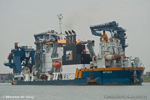
 Artemis
Current Status
Where is the vessel?
Artemis is currently in Near Karachi, based on AIS data received about 15h ago.
Latest AIS update:
Current position: 24.84137° N, 66.98299° E (Near Karachi)
Average speed (last 7 days): Loading…
Average speed (last 30 days): Loading…
Vessel profile: Artemis is a Dredger with dimensions 129m x 129m.
This page combines live AIS, route history, probable destination signals, nearby traffic, and port activity for practical vessel monitoring.
The current position of vessel Artemis is 24.84137 lat / 66.98299 lng. Updated: 2026-05-19 16:14:31 UTCNearest reference points:
- Near Kiamari
- Near PORT QASIM
- 16 nm S of Kiamari
Currently sailing under the flag of Netherlands ![]()
Artemis built in 2013 year
Deadweight:
2320 tDetails:
Live Vessel Artemis Analytics (details, animations, etc.)
Recent AIS points (UTC):
2026-05-19 13:24:13 UTC · 24.84086, 66.98327 · SOG 0 kn · COG -1°2026-05-19 13:30:29 UTC · 24.84086, 66.98326 · SOG 0 kn · COG 210°
2026-05-19 16:14:31 UTC · 24.84137, 66.98299 · SOG 0.4 kn · COG 227°
2026-05-19 16:14:31 UTC · 24.84137, 66.98299 · SOG 0.4 kn · COG 227°