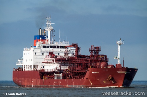
 Rhogas
Current Status
Where is the vessel?
Rhogas is currently in Near Molengat, based on AIS data received about 14h ago.
Latest AIS update:
Current position: 53.09194° N, 4.44876° E (Near Molengat)
Average speed (last 7 days): Loading…
Average speed (last 30 days): Loading…
Vessel profile: Rhogas is a Lpg Tanker with dimensions 113m x 19m.
This page combines live AIS, route history, probable destination signals, nearby traffic, and port activity for practical vessel monitoring.
The current position of vessel Rhogas is 53.09194 lat / 4.44876 lng. Updated: 2026-05-21 07:09:29 UTCNearest reference points:
- Near Molengat
- Near Den Helder
- Near de Waal
Currently sailing under the flag of Antigua Barbuda ![]()
Rhogas built in 2012 year
Deadweight:
8643 tDetails:
Live Vessel Rhogas Analytics (details, animations, etc.)
Recent AIS points (UTC):
2026-05-21 04:02:26 UTC · 52.54664, 3.78937 · SOG 12.1 kn · COG 44°2026-05-21 04:30:26 UTC · 52.61629, 3.89742 · SOG 12.4 kn · COG 44°
2026-05-21 05:53:52 UTC · 52.83451, 4.23184 · SOG 12.9 kn · COG 39°
2026-05-21 07:09:29 UTC · 53.09194, 4.44876 · SOG 14.3 kn · COG 34°