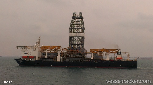
Ocean Blackhawk
Current StatusWhere is the vessel?
Ocean Blackhawk is currently in 31 nm S of Gulfmex Lightering Area, based on AIS data received about 15h ago.
Latest AIS update:
Current position: 27.23810° N, 90.81854° W (31 nm S of Gulfmex Lightering Area)
Average speed (last 7 days): Loading…
Average speed (last 30 days): Loading…
Vessel profile: Ocean Blackhawk is a Drilling Ship with dimensions 36m x 229m.
This page combines live AIS, route history, probable destination signals, nearby traffic, and port activity for practical vessel monitoring.
The current position of vessel Ocean Blackhawk is 27.23810 lat / -90.81854 lng. Updated: 2026-05-20 08:14:55 UTCNearest reference points:
- 94 nm S of Gulfmex Lightering Area
- 66 nm NW of Gulfmex Lightering Area
- 83 nm W of Gulfmex Lightering Area
Details:
Live Vessel Ocean Blackhawk Analytics (details, animations, etc.)
Recent AIS points (UTC):
2026-05-20 06:54:43 UTC · 27.23809, -90.81854 · SOG 0.1 kn · COG 135°2026-05-20 06:54:43 UTC · 27.23809, -90.81854 · SOG 0.1 kn · COG 135°
2026-05-20 08:14:55 UTC · 27.23810, -90.81854 · SOG 0.1 kn · COG 135°
2026-05-20 08:14:55 UTC · 27.23810, -90.81854 · SOG 0.1 kn · COG 135°