 vesseltracker.com
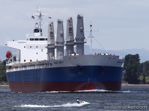
Ac Amity
Current StatusWhere is the vessel?
Ac Amity is currently in 69 nm SW of Harbor, based on AIS data received about 14h ago.
Latest AIS update:
Current position: 41.56833° N, 125.65167° W (69 nm SW of Harbor)
Average speed (last 7 days): Loading…
Average speed (last 30 days): Loading…
Vessel profile: Ac Amity is a General Cargo Ship with dimensions 28m x 181m.
This page combines live AIS, route history, probable destination signals, nearby traffic, and port activity for practical vessel monitoring.
The current position of vessel Ac Amity is 41.56833 lat / -125.65167 lng. Updated: 2026-05-18 07:45:45 UTCNearest reference points:
- Near Coos Bay
- 24 nm NE of Coos Bay
- Near Little River
Details:
Live Vessel Ac Amity Analytics (details, animations, etc.)
Recent AIS points (UTC):
2026-05-18 04:03:30 UTC · 42.37705, -125.68090 · SOG 12.9 kn · COG 172°2026-05-18 05:29:20 UTC · 42.05669, -125.65971 · SOG 13.1 kn · COG 176°
2026-05-18 07:26:52 UTC · 41.63406, -125.65400 · SOG 12.5 kn · COG 174°
2026-05-18 07:45:45 UTC · 41.56833, -125.65167 · SOG 12 kn · COG -1°