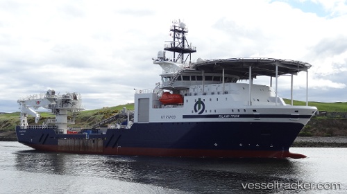
Island Pride
Current StatusWhere is the vessel?
Island Pride is currently in 43 nm SE of Gulfmex Lightering Area, based on AIS data received about 14h ago.
Latest AIS update:
Current position: 27.21500° N, 90.28500° W (43 nm SE of Gulfmex Lightering Area)
Average speed (last 7 days): Loading…
Average speed (last 30 days): Loading…
Vessel profile: Island Pride is a Offshore Support Vessel with dimensions 21m x 103m.
This page combines live AIS, route history, probable destination signals, nearby traffic, and port activity for practical vessel monitoring.
The current position of vessel Island Pride is 27.21500 lat / -90.28500 lng. Updated: 2026-07-03 01:20:32 UTCNearest reference points:
- 94 nm S of Gulfmex Lightering Area
- Near Port Fourchon
- Near FOURCHON
Details:
Live Vessel Island Pride Analytics (details, animations, etc.)
Recent AIS points (UTC):
2026-07-02 21:23:35 UTC · 27.22167, -90.28500 · SOG 0 kn · COG -1°2026-07-02 22:14:33 UTC · 27.22167, -90.28500 · SOG 0 kn · COG -1°
2026-07-02 23:36:42 UTC · 27.22008, -90.28599 · SOG 0 kn · COG -1°
2026-07-03 01:20:32 UTC · 27.21500, -90.28500 · SOG 0 kn · COG -1°