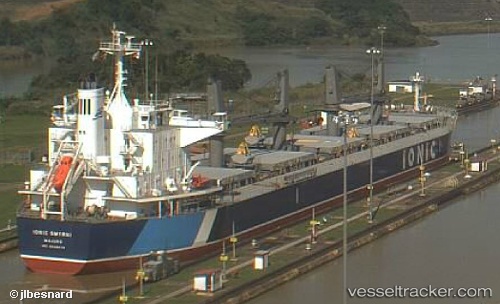
Ionic Smyrni
Current StatusWhere is the vessel?
Ionic Smyrni is currently in 94 nm NE of Alozaina, based on AIS data received about 14h ago.
Latest AIS update:
Current position: 37.36337° N, 13.06044° W (94 nm NE of Alozaina)
Average speed (last 7 days): Loading…
Average speed (last 30 days): Loading…
Vessel profile: Ionic Smyrni is a Bulk Carrier with dimensions 32m x 190m.
This page combines live AIS, route history, probable destination signals, nearby traffic, and port activity for practical vessel monitoring.
The current position of vessel Ionic Smyrni is 37.36337 lat / -13.06044 lng. Updated: 2026-05-25 16:49:38 UTCNearest reference points:
- 97 nm W of Los Ramos
- 95 nm W of Los Ramos
- 94 nm W of Los Ramos
Details:
Live Vessel Ionic Smyrni Analytics (details, animations, etc.)
Recent AIS points (UTC):
2026-05-25 13:04:28 UTC · 37.13171, -12.24808 · SOG 11.2 kn · COG 291°2026-05-25 13:57:26 UTC · 37.18715, -12.44111 · SOG 11 kn · COG 290°
2026-05-25 16:26:59 UTC · 37.34048, -12.97938 · SOG 10.4 kn · COG 288°
2026-05-25 16:49:38 UTC · 37.36337, -13.06044 · SOG 10.9 kn · COG 290°