 Whitefish Bay
Current Status
Where is the vessel?
Whitefish Bay is currently in 11 nm SE of De Tour Village, based on AIS data received about 15h ago.
Latest AIS update:
Current position: 45.81500° N, 83.77500° W (11 nm SE of De Tour Village)
Average speed (last 7 days): Loading…
Average speed (last 30 days): Loading…
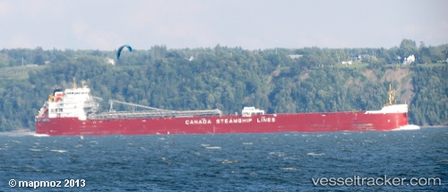
Vessel profile: Whitefish Bay is a Self Discharging Bulk Carrier with dimensions 225m x 25m.
This page combines live AIS, route history, probable destination signals, nearby traffic, and port activity for practical vessel monitoring.
The current position of vessel Whitefish Bay is 45.81500 lat / -83.77500 lng. Updated: 2026-05-19 20:27:07 UTCNearest reference points:
- Near Meldrum
- Near Mackinaw City
Currently sailing under the flag of Canada ![]()
Whitefish Bay built in 2013 year
Deadweight:
37690 tDetails:
Live Vessel Whitefish Bay Analytics (details, animations, etc.)
Recent AIS points (UTC):
2026-05-19 16:13:04 UTC · 46.39127, -84.23374 · SOG 8 kn · COG 160°2026-05-19 17:48:24 UTC · 46.21295, -84.15549 · SOG 7.6 kn · COG 129°
2026-05-19 19:56:03 UTC · 45.90471, -83.85992 · SOG 12.6 kn · COG 147°
2026-05-19 20:27:07 UTC · 45.81500, -83.77500 · SOG 12 kn · COG -1°