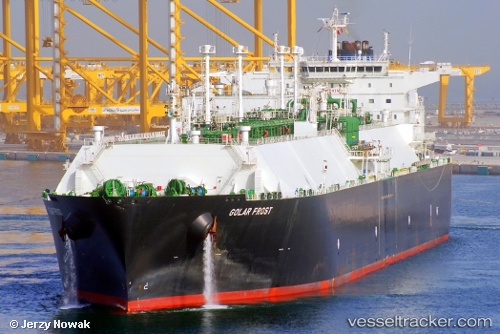
.
Vessel photo of Golar Frost (IMO 9655042) vesseltracker.com

Golar Frost

Vessel type: Lng Tanker | IMO: 9655042 | MMSI: MMSI: 538004975
Call sign: V7AE2 | Dimensions: 42 m x 280 m
Current Status

Where is the vessel?

Golar Frost is currently in 376 nm S of Diego Garcia, based on AIS data received less than 1h ago.

Latest AIS update:

Current position: 13.55833° S, 72.07333° E (376 nm S of Diego Garcia)

Average speed (last 7 days): Loading…

Average speed (last 30 days): Loading…

Vessel profile: Golar Frost is a Lng Tanker with dimensions 42m x 280m.

This page combines live AIS, route history, probable destination signals, nearby traffic, and port activity for practical vessel monitoring.

The current position of vessel Golar Frost is -13.55833 lat / 72.07333 lng. Updated: 2026-03-29 05:25:35 UTC
Nearest reference points:
  • Open sea, approx. 400 nm off the nearest listed port
  • Open sea, approx. 401 nm off the nearest listed port
  • Open sea (no nearby ports in database)
Details:

Live Vessel Golar Frost Analytics (details, animations, etc.)


Recent AIS points (UTC):
2026-03-28 23:34:32 UTC · -14.22833, 70.92500 · SOG 15 kn · COG -1°
2026-03-29 00:43:59 UTC · -14.07185, 71.19886 · SOG 15.9 kn · COG 58°
2026-03-29 03:43:31 UTC · -13.79333, 71.66833 · SOG 16 kn · COG -1°
2026-03-29 05:25:35 UTC · -13.55833, 72.07333 · SOG 16 kn · COG -1°

Track of the vessel in the last 28 days


UTC: --
Start: -- Track timeline (UTC) End: --
Encountered: --


Link to the map:


Find another ship

Golar_Frost (538004975) last ports (portcalls and passsages)

TANAH MERAH | 2025-08-30 04:38:07
BATU AMPAR | 2025-08-30 03:45:07
PULAU SAMBU | 2025-08-30 03:08:04
Rio Haina | 2025-07-24 14:49:49
BUKOM ISLAND | 2025-06-10 08:44:50
TANAH MERAH | 2025-06-10 07:52:26
PENGERANG | 2025-06-10 06:56:22
XIANTOULING | 2025-06-05 02:24:20
PENGERANG | 2025-05-26 06:54:06
TANAH MERAH | 2025-05-26 04:33:25
BATU AMPAR | 2025-05-26 04:09:57
RAS LAFFAN | 2025-05-14 04:10:54
Galle | 2025-05-01 04:00:51
JURONG ISLAND | 2025-04-13 03:02:53
TANAH MERAH | 2025-04-13 00:55:50
PENGERANG | 2025-04-12 23:48:57
DAECHEONHANG | 2025-02-24 04:26:50
BINTULU | 2025-02-10 00:24:45
BINTULU | 2025-01-21 02:57:10
PENGERANG | 2024-12-24 04:28:25
Singapore | 2024-12-24 01:41:51
PULAU SAMBU | 2024-12-24 01:18:23
POINT FORTIN | 2024-11-24 07:09:02
HOEK VAN HOLLAND | 2024-11-04 19:24:13
MAASVLAKTE - ROTTERDAM | 2024-11-04 18:43:48
Map Ta Phut | 2024-09-05 22:50:13
Gladstone Harbor | 2024-08-16 00:36:14
Da Chan Bay | 2024-07-15 05:36:39
Da Chan Bay | 2024-07-11 05:31:00
Da Chan Bay | 2024-07-07 05:26:11
Da Chan Bay | 2024-07-03 04:51:10
Da Chan Bay | 2024-06-26 07:26:38
Shekou | 2024-06-26 05:47:52
Selat Lombok | 2024-05-27 12:35:55
Batangas | 2024-05-20 00:32:56
Singapore | 2024-05-10 22:11:18
Gladstone Harbor | 2024-04-09 03:20:22
Map Ta Phut | 2024-03-12 23:47:46
St. Georges | 2024-02-12 08:55:30
Singapore | 2023-12-20 22:08:01
Map Ta Phut | 2023-12-17 07:19:51
Port Louis | 2023-10-07 00:34:33
Singapore | 2023-09-28 13:21:33
Higashi-Iwase | 2023-09-20 03:43:04
Kobe | 2023-09-19 05:13:00
Selat Lombok | 2023-07-27 03:06:50
Map Ta Phut | 2023-07-18 23:36:46
Singapore | 2023-07-05 05:41:28
Sambu | 2023-07-05 05:24:54
Algeciras | 2023-04-27 23:14:42
Strait Of Gibraltar | 2023-04-27 03:44:48
Calais | 2023-02-18 08:08:17
Port Louis | 2023-01-12 11:55:12
Oita | 2022-08-12 01:30:45
Singapore | 2022-06-29 04:47:50
Yosu | 2022-06-21 22:58:28
Yokosuka | 2022-06-10 04:26:31
Yokohama | 2022-06-09 01:32:11
Subic Bay | 2022-04-10 07:15:11
Subic Bay | 2022-04-10 00:18:09
Yokkaichi | 2022-02-21 03:35:04
Higashi-Iwase | 2022-01-24 04:50:03
Panama | 2021-12-29 23:55:20
Panama | 2021-12-29 23:40:20
Balboa | 2021-12-29 19:40:09
Cristobal | 2021-12-28 13:00:02