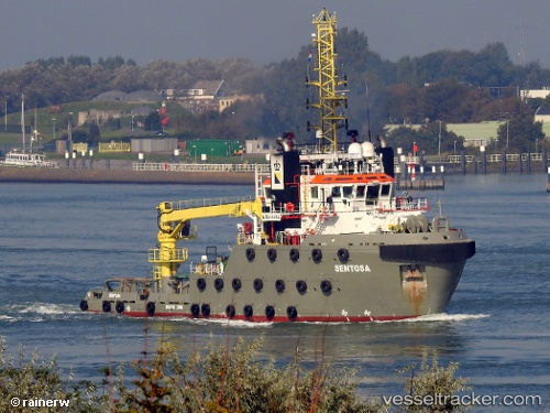
 SEA SENTOSA
Current Status
Where is the vessel?
SEA SENTOSA is currently in 61 nm S of Sabine Pass, based on AIS data received about 14h ago.
Latest AIS update:
Current position: 28.71833° N, 93.67333° W (61 nm S of Sabine Pass)
Average speed (last 7 days): Loading…
Average speed (last 30 days): Loading…
Vessel profile: SEA SENTOSA is a Reserved with dimensions m x m.
This page combines live AIS, route history, probable destination signals, nearby traffic, and port activity for practical vessel monitoring.
The current position of vessel SEA SENTOSA is 28.71833 lat / -93.67333 lng. Updated: 2026-05-24 23:54:47 UTCNearest reference points:
- 45 nm SE of Galveston
- 40 nm SE of Galveston
- 43 nm SE of Sheppard
Currently sailing under the flag of Netherlands ![]()
Details:
Live Vessel SEA SENTOSA Analytics (details, animations, etc.)
Recent AIS points (UTC):
2026-05-24 20:07:30 UTC · 28.97174, -93.91360 · SOG 5 kn · COG 137°2026-05-24 21:27:47 UTC · 28.88333, -93.82667 · SOG 5 kn · COG -1°
2026-05-24 22:06:47 UTC · 28.83833, -93.78500 · SOG 5 kn · COG -1°
2026-05-24 23:54:47 UTC · 28.71833, -93.67333 · SOG 4 kn · COG -1°