Clear Sky
Current StatusWhere is the vessel?
Clear Sky is currently in 53 nm S of Maspalomas, based on AIS data received about 14h ago.
Latest AIS update:
Current position: 26.86890° N, 15.49814° W (53 nm S of Maspalomas)
Average speed (last 7 days): Loading…
Average speed (last 30 days): Loading…
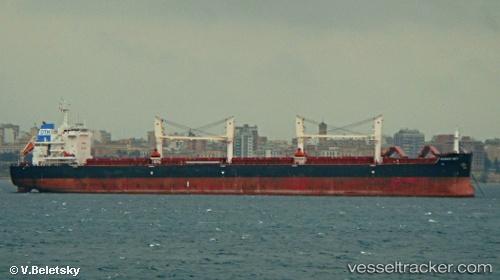
Vessel profile: Clear Sky is a Bulk Carrier with dimensions 32m x 200m.
This page combines live AIS, route history, probable destination signals, nearby traffic, and port activity for practical vessel monitoring.
The current position of vessel Clear Sky is 26.86890 lat / -15.49814 lng. Updated: 2026-05-20 13:36:22 UTCNearest reference points:
- 33 nm SE of San Agustin
- Near TALIARTE
- 22 nm S of San Agustin
Details:
Live Vessel Clear Sky Analytics (details, animations, etc.)
Recent AIS points (UTC):
2026-05-20 10:33:33 UTC · 26.39093, -15.72839 · SOG 10.3 kn · COG 24°2026-05-20 11:41:33 UTC · 26.56802, -15.64302 · SOG 10 kn · COG 24°
2026-05-20 13:24:33 UTC · 26.83714, -15.51438 · SOG 10.5 kn · COG 24°
2026-05-20 13:36:22 UTC · 26.86890, -15.49814 · SOG 10.5 kn · COG 24°