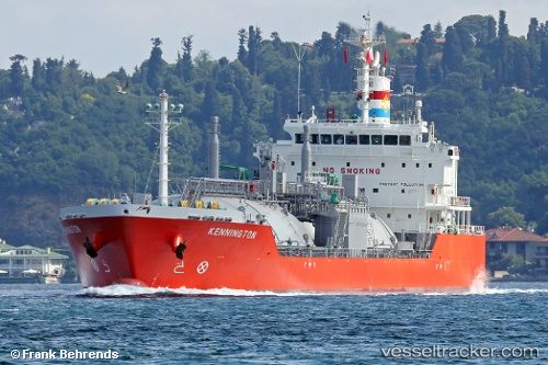
 Kennington
Current Status
Where is the vessel?
Kennington is currently in Near Pointe a la Hache, based on AIS data received about 14h ago.
Latest AIS update:
Current position: 29.58749° N, 89.82451° W (Near Pointe a la Hache)
Average speed (last 7 days): Loading…
Average speed (last 30 days): Loading…
Vessel profile: Kennington is a Lpg Tanker with dimensions 120m x 20m.
This page combines live AIS, route history, probable destination signals, nearby traffic, and port activity for practical vessel monitoring.
The current position of vessel Kennington is 29.58749 lat / -89.82451 lng. Updated: 2026-05-21 04:36:57 UTCNearest reference points:
- Near Pointe a la Hache
- Near Port Sulphur
- 11 nm NE of Port Sulphur
Currently sailing under the flag of Singapore ![]()
Kennington built in 2013 year
Deadweight:
8556 tDetails:
Live Vessel Kennington Analytics (details, animations, etc.)
Recent AIS points (UTC):
2026-05-21 02:03:54 UTC · 29.58755, -89.82453 · SOG 0 kn · COG 303°2026-05-21 02:18:59 UTC · 29.58754, -89.82458 · SOG 0 kn · COG 306°
2026-05-21 03:41:54 UTC · 29.58667, -89.82333 · SOG 0 kn · COG -1°
2026-05-21 04:36:57 UTC · 29.58749, -89.82451 · SOG 0 kn · COG 309°