 vesseltracker.com
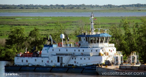
 HB AQUARIUS
Current Status
Where is the vessel?
HB AQUARIUS is currently in Near CIUDAD DE CORRIENTES, based on AIS data received about 14h ago.
Latest AIS update:
Current position: 27.52387° S, 58.87539° W (Near CIUDAD DE CORRIENTES)
Average speed (last 7 days): Loading…
Average speed (last 30 days): Loading…
Vessel profile: HB AQUARIUS is a Pusher Tug with dimensions 55m x 350m.
This page combines live AIS, route history, probable destination signals, nearby traffic, and port activity for practical vessel monitoring.
The current position of vessel HB AQUARIUS is -27.52387 lat / -58.87539 lng. Updated: 2026-05-17 22:13:46 UTCNearest reference points:
- Near Asunción
- 88 nm N of Campo Largo
Currently sailing under the flag of Bolivia ![]()
HB AQUARIUS built in 2014 year
Deadweight:
1000 tDetails:
Live Vessel HB AQUARIUS Analytics (details, animations, etc.)
Recent AIS points (UTC):
2026-05-17 19:07:21 UTC · -27.33309, -58.65455 · SOG 6.6 kn · COG 183°2026-05-17 19:59:39 UTC · -27.37144, -58.74965 · SOG 6.8 kn · COG 257°
2026-05-17 22:06:41 UTC · -27.52218, -58.87922 · SOG 2.9 kn · COG 55°
2026-05-17 22:13:46 UTC · -27.52387, -58.87539 · SOG 1.9 kn · COG 351°