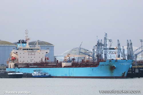
 Maersk Tampa
Current Status
Where is the vessel?
Maersk Tampa is currently in 79 nm SW of Loreto, based on AIS data received about 14h ago.
Latest AIS update:
Current position: 24.94799° N, 113.45539° W (79 nm SW of Loreto)
Average speed (last 7 days): Loading…
Average speed (last 30 days): Loading…
Vessel profile: Maersk Tampa is a Chemical Oil Products Tanker with dimensions 183m x 32m.
This page combines live AIS, route history, probable destination signals, nearby traffic, and port activity for practical vessel monitoring.
The current position of vessel Maersk Tampa is 24.94799 lat / -113.45539 lng. Updated: 2026-06-17 17:37:15 UTCNearest reference points:
- 38 nm W of Loreto
- 73 nm W of Los Cabos
- 71 nm W of Los Cabos
Currently sailing under the flag of Denmark ![]()
Details:
Live Vessel Maersk Tampa Analytics (details, animations, etc.)
Recent AIS points (UTC):
2026-06-17 14:13:24 UTC · 25.50972, -113.94416 · SOG 12.6 kn · COG 139°2026-06-17 16:07:42 UTC · 25.19272, -113.67862 · SOG 12.7 kn · COG 137°
2026-06-17 17:08:50 UTC · 25.02833, -113.52167 · SOG 12 kn · COG -1°
2026-06-17 17:37:15 UTC · 24.94799, -113.45539 · SOG 12.9 kn · COG 141°