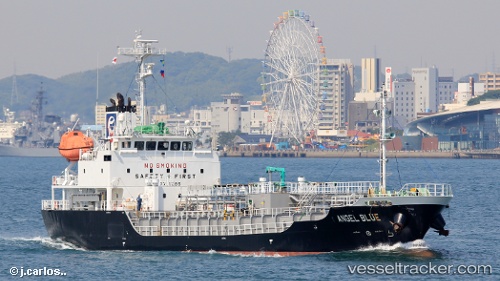
 Angel Blue
Current Status
Where is the vessel?
Angel Blue is currently in Near Hakata, based on AIS data received about 14h ago.
Latest AIS update:
Current position: 33.63309° N, 130.32756° E (Near Hakata)
Average speed (last 7 days): Loading…
Average speed (last 30 days): Loading…
Vessel profile: Angel Blue is a Bitumen Tanker with dimensions 74m x 12m.
This page combines live AIS, route history, probable destination signals, nearby traffic, and port activity for practical vessel monitoring.
The current position of vessel Angel Blue is 33.63309 lat / 130.32756 lng. Updated: 2026-05-21 01:37:18 UTCNearest reference points:
- Near Hakata
- Near Hibiki-Nada
- Near KITAKYUSHU
Currently sailing under the flag of Panama ![]()
Details:
Live Vessel Angel Blue Analytics (details, animations, etc.)
Recent AIS points (UTC):
2026-05-20 22:53:54 UTC · 33.63366, 130.32761 · SOG 0.1 kn · COG 251°2026-05-21 00:22:54 UTC · 33.63354, 130.32770 · SOG 0 kn · COG 256°
2026-05-21 01:19:18 UTC · 33.63326, 130.32767 · SOG 0.2 kn · COG 272°
2026-05-21 01:37:18 UTC · 33.63309, 130.32756 · SOG 0.2 kn · COG 284°